So Cal Mountain Weather and Road condition links.

MTN FX

Mountain Man
Premium
Location
Big Bear City,Ca.
Car
2004 FX35 AWD
Name
John Green
Here are some Mountain weather and road condition links.

http://kbhr933.com/weather-roads/big-bear-roads/

http://rimoftheworld.net/

http://www.dot.ca.gov/cgi-bin/roads.cgi

Tire Chain Key
R-0: No chains required
R-1: Chains required, unless you have snow tires
R-2: Chains required, except on 4-wheel-drives with snow tires on all four wheels
R-3: Chains required, no exceptions
IT’S THE LAW: Carry tire chains at all times during winter travel in the mountains!
This page is updated as new information becomes available.
 
Big Bear Road closure update

Despite ‘Round-the-Clock Snow Removal Efforts of CalTrans and Acosta Company, Arctic Circle Portion of Highway 18 Closed Until Friday Evening

February 19, 2009 by Catherine Sandstrom
Filed under ALERTS, Current News, Roads/Travel, Snow/Weather


Three snow removal teams have been at work all night, in an effort to clear snow from the Arctic Circle portion of Highway 18, on the seven mile or so stretch from the Big Bear Dam to Snow Valley, in hopes of having the road re-opened in time for the weekend. More than 30 slides and snow drifts have crossed the roadway since Monday, and some of these piles of snow are as much as 15 feet deep. CalTrans has had up to three snowblowers, several loaders, and snow plows on Highway 18, just to keep a path for emergency access and the contractor hired under an emergency contract which, again, is the A.J. Acosta Company based in Big Bear Lake (the same contractor who cleared the Artic Circle of avalanche snow last week). In a conversation with Andy Acosta this morning, he tells KBHR, “We have twice as much snow as last time, and this is heavier snow.” CalTrans has estimated that, with the assistance of the Acosta Company and another from Beaumont, Highway 18 may be re-opened by Friday evening to accommodate weekend traffic to the Big Bear Valley. Says Acosta, “We worked through the night, 24 hours, and we’re going to keep working until they tell us to stop, or the road is opened.”
So though Highway 18 down the front grade to Highway 330 remains closed today, the eastern end of Highway 18 to Lucerne Valley is open and free of chain requirements as of yesterday afternoon. Highway 38 through Angelus Oaks, as well as all roads within the Big Bear Valley, remain under an R2 requirement, so you must have chains on the drive wheels of your vehicle, unless in a four-wheel drive with snow tires and carrying chains. Local roads are icy this morning, so allow extra time and proceed with caution.
 
Hey MTN - thanks for the updates, Im sure all the SoCal guys appreciate it! Keep up the good work bro!
 
Update

Highway 18, West of the Dam, Still Closed as of Friday Morning — Update: Now Open!

February 20, 2009 by Catherine Sandstrom
Filed under Current News, Roads/Travel, Snow/Weather


bigbeardam-thumb.png
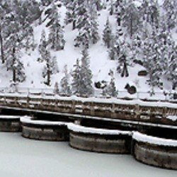
Crews have continued to work ’round the clock to clear avalanche snow from the Arctic Circle portion of Highway 18, between the Big Bear Dam and Snow Valley, in hopes of having to roadway open to weekend traffic—though, for the time being, the front grade of Highway 18 remains closed. Keep it tuned to KBHR 93.3 FM today, as we will bring you updates on the re-opening of Highway 18 and our road conditions as information becomes available. As emergency snow removal contractor Andy Acosta told us yesterday, “We’re going to keep working until they tell us to stop, or the road is opened.”
For the time being [as of 9am], limited chain controls do remain in effect for the west end of the Valley; R2 chain requirements apply to Highway 18, or Big Bear Boulevard, from Pine Knot Avenue in the Village west to the Big Bear Dam through Boulder Bay, as well as the North Shore portion of Highway 38 west from Stanfield Cutoff through the Fawnskin area. This R2 requirement means that you must have chains on the drive wheels of your vehicle, unless in a four-wheel drive with snow tires on all four wheels and carrying chains. If coming or going from the mountain today, Highway 18 west to Lucerne Valley and Highway 38 through Angelus Oaks are open and free of chain requirements [again, as of 9am].
Update: We have some very exciting news on our road situation as of this afternoon. Despite Governor Schwarzenegger’s mandated Friday furloughs for CalTrans employees, local CalTrans crews, as well as the Big Bear-based A.J. Acosta Company, have worked tirelessly to clear the Arctic Circle portion of Highway 18 of avalanche snow, and as of noon today, Highway 18 is officially re-opened! Highway 18 had been closed since Monday, due to avalanches which resulted in snow drifts as deep as 15 feet on the seven-or-so mile stretch from the Big Bear Dam to Snow Valley. Just a week earlier, the Arctic Circle had been closed for three days, also due to avalanche snow. But, again, as of this time, Highway 18 is open to motorists, and in time to accommodate weekend visitors to the Big Bear Valley. Highway 38 to Redlands and Highway 18 to Lucerne Valley are also open, and free of chain requirements.
 

Attachments

  • bigbeardam-thumb.png
    bigbeardam-thumb.png
    7.5 KB · Views: 38
im leaving for your neck of the woods about 8pm tonight... i drive it all the time but i dont know which way is which... the front way is through the arctic circle? hwy 18/330 (i hear my friends with cabins say that all the time)... this is still closed?? can i come up the back way.. not the one from the 15 but the other one... hwy 38?
ive never taken the bear valley cutoff/victorville/ 18 way... seems way outta the way but you are the resident expert....
please let me know soon...

edit... never mind... reread the the bottom of the second post.... YAY open roads
 
Last edited:
All roads open!

All roads open at this time.And yes 330/18 is the front way. The other front way is through Redlands on the 10 get off at University go left past university of Redlands to Lugonia turn right and stay on this road it will turn into hwy 38 and take you all the way to east end of big bear valley turn left on Big Bear Blv and this will take you right into town. Hwy 38 is a little further but a lot less traffic and banked corners much more fun drive!!!
 
i normally go up the front and down the other front way... i prefer the back way but im normally in such an anxious rush to get there every mile less counts...
 
Last edited:
Your probably right about that for tonight but if you ever come up during the daytime HWY 38 is considered the senic route goes by San Gorgonio and like I said allot more fun to drive.
 
Back
Top